Franchising with confidence

How Liverpool City Region designed and evidenced its new bus network with Podaris

In September 2026, buses in St Helens came back under public control for the first time since deregulation. This is the story of how LCRCA designed the new network, built the evidence to defend it, and worked with operators to deliver it – and why the same approach is now shaping far more than the bus network.

Yellow and black metro bus labeled X3 to St Helens parked at bus stand 3 with a glass bus shelter on the right and a blue double-decker bus in the background.
40,000
more residents within an hour of Arrowe Park Hospital
25,000
more residents within an hour of Liverpool John Lennon Airport via the new X3 express
2027
the whole city region back under public control

A generational opportunity

Bus franchising is a once-in-a-generation shift. For the first time since deregulation, a combined authority decides where its buses go, how often they run and what a ticket costs.

LCRCA made a public promise that no passenger would be worse off on day one. Every route change and every new connection had to be shown as an improvement – to members, to residents and to the operators bidding for the contracts – with the numbers to back it up.

There are many ways to franchise a network. LCRCA's started with who can get where, and designed outwards from there. Podaris has been the authority's transport planning platform since 2024, and we're proud to have supported the franchising journey from the network sketches through to procurement. It's exactly what franchising should be about.

"Franchising is as much about confidence as it is about buses. Members, operators and the public all needed to see that our decisions were grounded in evidence, and tools like Podaris gave the team the ability to show that, quickly, visually, and collaboratively."

Kara Wood Head of Franchising, LCRCA

Four problems and a fixed deadline

Franchising handed LCRCA's network planning team several jobs at once, all of them time-critical and all of them in public:

  • Proving the value: franchising was always expected to cost more than the commercial model it replaced, so members and the public needed to see what that money bought. The team's previous tooling only produced static maps, and reading the detail on a whole-network plan meant printing it on A0 – fine for a single design, less so for showing multiple iterations to a non-technical audience
  • Measuring who can reach what: LCRCA's design principles included a 400-metre standard so that every resident lives within a short walk of a stop, but proximity to a stop says nothing about where the bus goes. The team also needed to measure access to real destinations, hospitals in particular, and show how the new network changed it
  • Iterating without the queue: testing a network change had previously meant packaging up a request for another team and waiting a week or more for the results, which doesn't work when the programme is on the clock
  • Bringing operators up to speed: bidders unfamiliar with the region needed clear, consistent information on every route variant, ideally without burying LCRCA's transport information team under clarification questions

"We wanted to be able to constantly look at things, change things, review and build on each iteration – not rely on another team to package up a work package and get it back a week later."

Simon Ackers Lead Network Planner, LCRCA

Testing the network in-house

Simon's team evaluated several tools during procurement and chose Podaris on what he calls "the key thing – the ease, the simplicity, the speed." The team brought the existing network into Podaris and started changing it directly, merging routes, adjusting frequencies and trying new connections, with each edit visible as soon as it was made. Without a dependency on anyone else's workload, several variants could be evaluated in the time it had previously taken to get results back on one.

Satellite map showing a bus route from St Helens to Liverpool John Lennon Airport with stops labeled, displayed with a yellow dashed line and several stops highlighted along the route; the map interface includes editing tools and service options for managing the route pattern and stops.
Editing route patterns and stops directly on the map in Podaris:Plan, here, the X3 alignment between St Helens and Liverpool John Lennon Airport.

"Without that reliance on other people – having to keep badgering them, or waiting for a result to come back – it was just there, and we could do it."

— Simon Ackers

Turning edits into evidence

Each version of the network was then run through accessibility analysis, with isochrones layered over census data to show how many residents could reach key destinations and how long it took them. The team could zoom in or out as needed, from whole-network access down to what a single route did for a single neighbourhood.

The result that stuck was Arrowe Park Hospital, where the proposed network brings an additional 40,000 residents within a 60-minute direct journey.

The same approach shaped what launched on day one. The X3 express, a brand-new direct service from St Helens to Liverpool John Lennon Airport, began running on 6 September – the first day of public control – and puts more than 25,000 additional residents within an hour of the airport, rising to over 100,000 within 80 minutes once onward rail and bus connections are counted. It's a direct link that didn't exist before public control, and the sort of connection the network was designed to find.

Yellow and black Metro bus with route X3 to St Helens parked at bus stand 3 next to a glass shelter with a bench on a cloudy day.
The X3, in the first week of public control.

"An additional 40,000 people within 60 minutes of Arrowe Park – that's really powerful. Having the data both on the map and in the numbers is what gets through to people. It shows there are real benefits."

Simon Ackers Lead Network Planner, LCRCA

Sharing it with operators

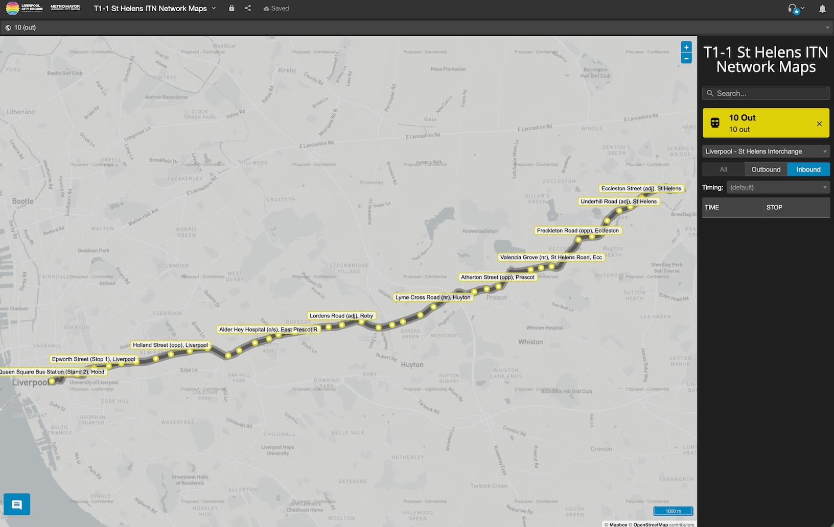
Rather than issuing bidders a set of static PDFs, LCRCA gave them interactive route maps they could zoom into and cross-reference against stop data for themselves. Clarification questions dropped dramatically, and when an error did surface it was corrected once, immediately, rather than reissued as a fresh document pack.

A franchised network also has to be one that operators of every size can bid for and run. Smaller operators don't necessarily have dedicated scheduling software, so giving them interactive maps and stop data through Podaris:Engage meant they could work from exactly the same information as the larger bidders, without needing a system of their own to read it.

Map of bus route 10 outbound from Liverpool to St Helens, showing stops at Queen Square Bus Station Liverpool, Epworth Street, Holland Street, Alder Hey Hospital, Lordens Road, Lyme Cross Road, Atherton Street, Valencia Grove, Freckleton Road, Underhill Road, and Eccleston Street.
The outbound route 10 view shared with bidders, with every stop listed alongside the map.

"Being able to share the route maps and stop information with bidders using Podaris:Engage has been a really useful tool to provide an extra level of clarification."

— Simon Ackers

"It's genuinely made my job easier."

Simon Ackers Lead Network Planner, LCRCA

The same evidence base, across the authority

Combined authorities are doing a great deal more of their own strategic planning than they were five years ago, and LCRCA's Transport Development team – several of whom joined from consultancy and brought that way of working with them – now use the same Podaris platform for scheme development well beyond the bus network, including corridor options for the region's new Rapid Transit system.

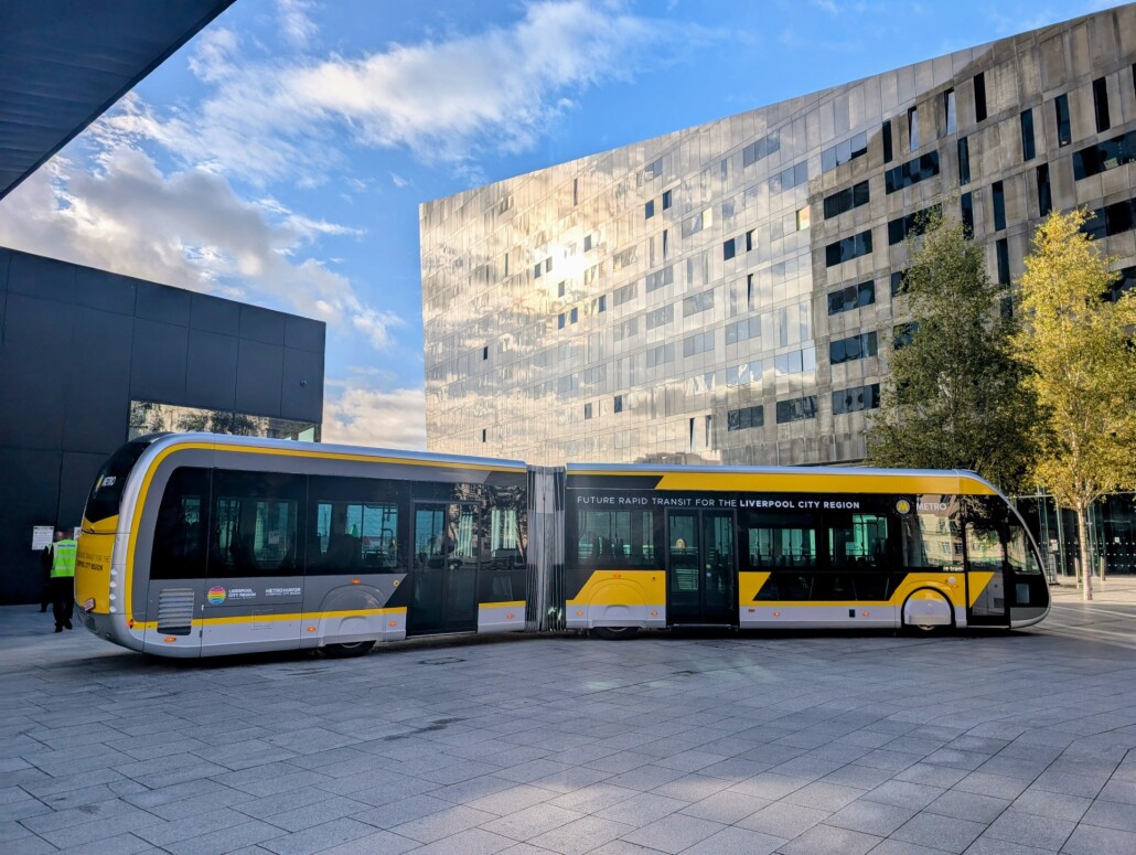
Yellow and black articulated bus parked in an urban plaza with modern glass and concrete buildings and trees in the background under a partly cloudy blue sky.

"Faced with a challenging deadline, Podaris enabled us to quickly develop and appraise multiple Rapid Transit corridor alignments using a wide range of demographic, economic and development pipeline indicators. Interactive visual outputs allowed senior stakeholders to interrogate findings and test assumptions in real time. Within approximately one hour, we had produced a robust, decision-ready evidence base that informed strategic decision-making."

Connor Burns Transport Development Analyst, LCRCA

From network design to digital twin

Franchising established the network; the next job is keeping it honest. LCRCA is a partner in KUDATA, the Innovate UK and KAIA-funded Korea–UK Digital Twin Approach for Transport Analysis, alongside Podaris and the University of Liverpool. The project is developing AI-driven digital twins with social equity at their centre, so that the authority can keep measuring, and improving, who the network serves long after launch day.

Planning a bus network?

Tick box
Scalable low-cost per-user pricing
Tick box
Dedicated support available
Book a demo