NEW: Introducing Street Editing for Podaris:Plan
Find out more...

NEW: Street editing for Podaris:Plan
Nobody plans a bus network in isolation. So why plan the streets that way?
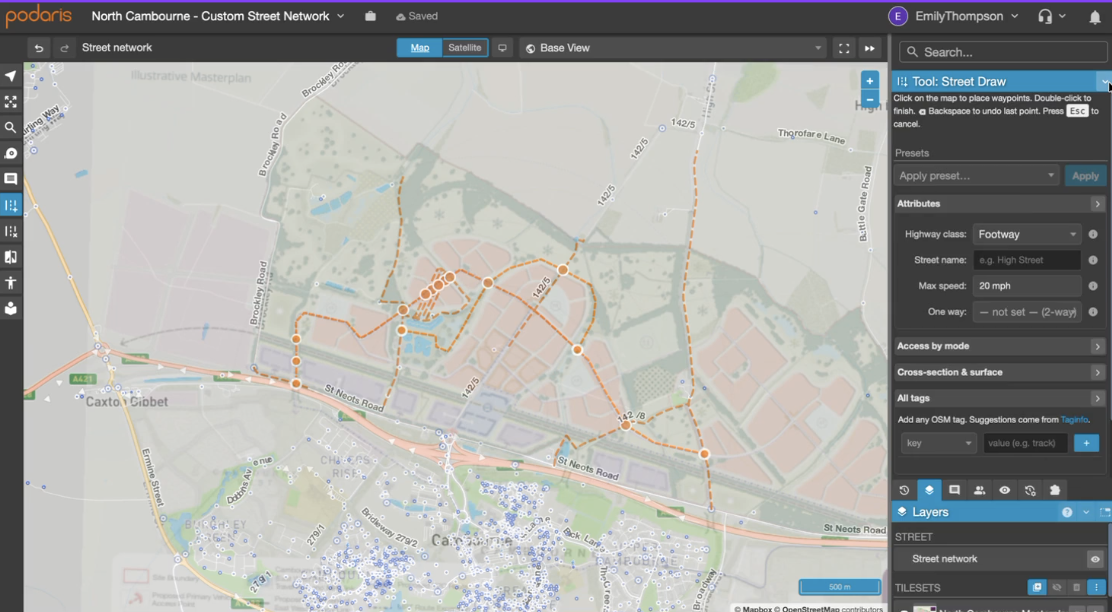
Street editing brings the physical network into Podaris:Plan, so you can geo-reference a masterplan, edit the street network, run isochrones, layer in your own data and take it all the way through to accessibility analysis in Podaris:Insight, without switching tools once.
One workflow, not five tools
Until now, the street network in a Podaris project was something you imported and then left alone. If a scheme called for a road network changes, the edit had to be made elsewhere and brought back in. For anyone working on active travel schemes, new developments or bus priority measures, that round trip was a constant source of friction.
Now you can do that directly within Podaris. The edited network is immediately available for isochrone and accessibility analysis, so the journey from a change on the map to a result you can share with stakeholders happens in one collaborative place.
Now you can do that directly within Podaris. The edited network is immediately available for isochrone and accessibility analysis, so the journey from a change on the map to a result you can share with stakeholders happens in one collaborative place.
Every street edit becomes evidence

Streets in Podaris are not a static backdrop: they are the network your routes run along, which means that when you edit a street, every route that uses it responds. Divert a corridor once and each pattern passing through it updates automatically, with travel times, fleet requirements and costs recalculated as you go.
This is what turns a drawing into something you can use in a business case. Close a road to through traffic and see what it does to the route serving it. Add a bus gate and find out how much run time it saves, and who gains or loses access as a result. Because the edit, the analysis and the presentation all live in the same project, the numbers stay in step with the scheme, and there is no reassembling of outputs from several tools before a submission.
This is what turns a drawing into something you can use in a business case. Close a road to through traffic and see what it does to the route serving it. Add a bus gate and find out how much run time it saves, and who gains or loses access as a result. Because the edit, the analysis and the presentation all live in the same project, the numbers stay in step with the scheme, and there is no reassembling of outputs from several tools before a submission.
You don't need a public transport network to start
.png)
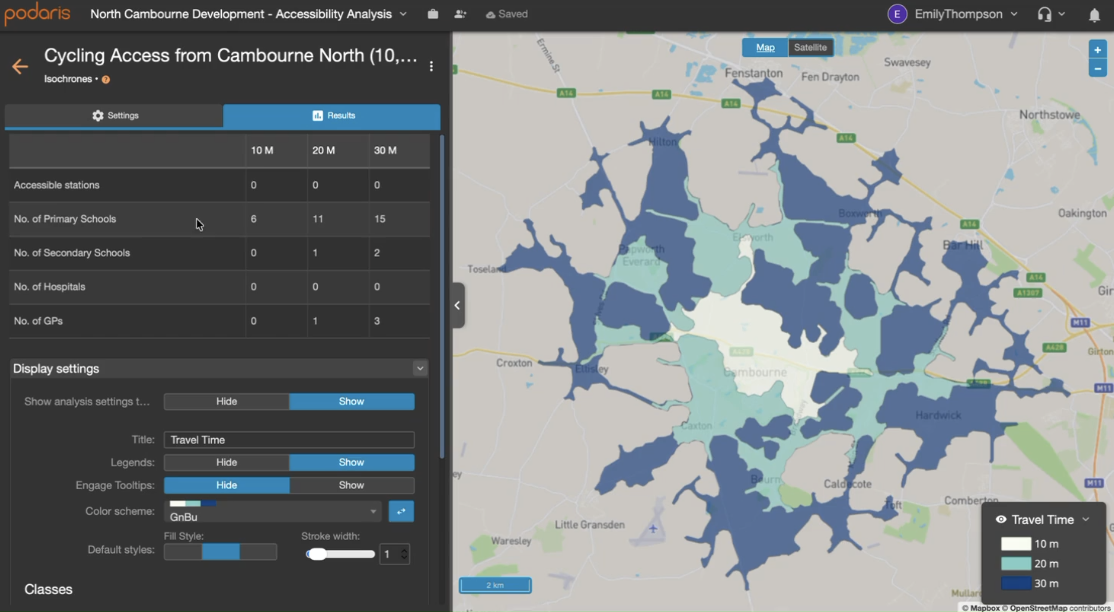
Street editing also opens Podaris to work that has never depended on a bus timetable. If you are assessing a housing site, modelling a new active travel link, testing a low-traffic neighbourhood or preparing a transport assessment for a planning application, you can begin with the streets and build the analysis from there.
Trace a masterplan over a geo-referenced drawing, lay out the access roads and footpaths, and run walking and cycling isochrones straight away to see how many future residents can reach the nearest stop or the town centre within a given time. When public transport enters the picture, it is already there: add a route, or import a GTFS or TransXChange feed, and the same street network carries both.
Trace a masterplan over a geo-referenced drawing, lay out the access roads and footpaths, and run walking and cycling isochrones straight away to see how many future residents can reach the nearest stop or the town centre within a given time. When public transport enters the picture, it is already there: add a route, or import a GTFS or TransXChange feed, and the same street network carries both.
Schedule a demo today

Scalable low-cost per-user pricing
Dedicated support available
© 2026 Podaris Limited

